


![“[Building nerf blasters] became this outlet of creativity for me that hasn't been matched by anything else. The process [of] making a build complete to your desire is such a painstakingly difficult process, but I've had to learn from [the skills needed from] soldering to proper painting. There's so many different options for everything, if you think about it, it exists. The best part is [that] if it doesn't exist, you can build it yourself," Ishaan Parate said.](https://harkeraquila.com/wp-content/uploads/2022/08/DSC_8149-900x604.jpg)


![“When I came into high school, I was ready to be a follower. But DECA was a game changer for me. It helped me overcome my fear of public speaking, and it's played such a major role in who I've become today. To be able to successfully lead a chapter of 150 students, an officer team and be one of the upperclassmen I once really admired is something I'm [really] proud of,” Anvitha Tummala ('21) said.](https://harkeraquila.com/wp-content/uploads/2021/07/Screen-Shot-2021-07-25-at-9.50.05-AM-900x594.png)


![“I think getting up in the morning and having a sense of purpose [is exciting]. I think without a certain amount of drive, life is kind of obsolete and mundane, and I think having that every single day is what makes each day unique and kind of makes life exciting,” Neymika Jain (12) said.](https://harkeraquila.com/wp-content/uploads/2017/06/Screen-Shot-2017-06-03-at-4.54.16-PM.png)


![“My slogan is ‘slow feet, don’t eat, and I’m hungry.’ You need to run fast to get where you are–you aren't going to get those championships if you aren't fast,” Angel Cervantes (12) said. “I want to do well in school on my tests and in track and win championships for my team. I live by that, [and] I can do that anywhere: in the classroom or on the field.”](https://harkeraquila.com/wp-content/uploads/2018/06/DSC5146-900x601.jpg)
![“[Volleyball has] taught me how to fall correctly, and another thing it taught is that you don’t have to be the best at something to be good at it. If you just hit the ball in a smart way, then it still scores points and you’re good at it. You could be a background player and still make a much bigger impact on the team than you would think,” Anya Gert (’20) said.](https://harkeraquila.com/wp-content/uploads/2020/06/AnnaGert_JinTuan_HoHPhotoEdited-600x900.jpeg)

![“I'm not nearly there yet, but [my confidence has] definitely been getting better since I was pretty shy and timid coming into Harker my freshman year. I know that there's a lot of people that are really confident in what they do, and I really admire them. Everyone's so driven and that has really pushed me to kind of try to find my own place in high school and be more confident,” Alyssa Huang (’20) said.](https://harkeraquila.com/wp-content/uploads/2020/06/AlyssaHuang_EmilyChen_HoHPhoto-900x749.jpeg)


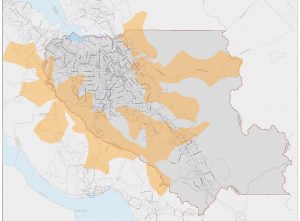
PG&E to shut off power in 17 Northern California counties in second public safety power shutoff of the month

Provided by PG&E
A map of regions that will potentially be affected by the public safety power shutoff.
October 23, 2019
Pacific Gas and Electric Company (PG&E) officials announced today that the utility will be moving forward with this month’s second round of public safety power shutoffs (PSPS) today, turning off power to parts of 17 counties in Northern California, in response to warnings of dry, hot and windy weather and increased wildfire dangers.
Parts of San Mateo County, the North Bay and Kern County were affected starting at 2 p.m. today, with subsequent rounds of shutoffs continuing until 1 a.m. on Thursday. An estimated total of 179,000 customers are expected to be affected by this event. Weather forecasts currently suggest that the wind event will fully subside by Friday.
This shutoff follows the PSPS earlier this month, which began on Oct. 9 and lasted up to three days in some areas. At the time of the previous shutoff, PG&E claimed that they did not foresee any future PSPS events, although the conditions were subject to change depending on the weather.
“This is not the future any of us want to live in. Our goal over time is to reduce wildfire risk further across the system, to shut off power less frequently and to further minimize the impact of shutoffs,” PG&E CEO Bill Johnson said at a press conference on Oct. 10 following this month’s first power shutoff. “Given the risk to public safety and the desire to have zero spark during conditions like the ones we’ve had over the last several days, we are very likely to have to make this kind of decision again in the future.”
Any customers who will be impacted by this shutoff event were notified by PG&E via call, text, or email, and the utility had stated that it will continue updating customers on the current situation. Customers can check the potential PSPS map provided by PG&E for estimated regions of impact.